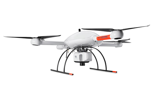
mdLiDAR3000

mdLiDAR3000

Plan, fly, process and visualise!

The mdLiDAR3000 solution is a fully integrated package that provides professionals with the aircraft, payload, software and support required to quickly and reliably produce point cloud visualisations. Ideal for land surveying, mining, oil and gas, and construction applications. This solution uses the efficiency, resilience and lifting power of the md4-3000 to carry a perfectly integrated Sony RX1R II 42.4 megapixel camera and Riegl miniVUX-1UAV (or optional miniVUX-1DL) LiDAR payload to acquire accurate and high density LiDAR data in the field and turn it into a 3D colourised point cloud with the assistance of mdLiDAR processing software and POSPac UAV DG software. Operated in the field using professional controls and telemetry, in conjunction with mdCockpit tablet software that allows you to plan your survey area and monitor flight progress at the swipe of a finger, the mdLiDAR3000 is an efficient, flexible and accurate LiDAR surveying solution.

Key Features:

  • Robust and reliable construction
  • Rain, sand, salt and heat resistant
  • Rugged carrying case
  • Easy to deploy and operate
  • Improved efficiency with a high quality German engineered system
  • Failsafe motors for minimum downtime
  • Stable flight for precise results
  • Professional controls and telemetry

  • Specifications:

  • Weight: approx. 14 kg
  • Sensor: 42.4 megapixel Sony RX1R II camera with custom quick release mount, and Riegl miniVUX-1UAV or miniVUX-1DL
  • LiDAR point cloud accuracy: horizontal 1 – 3 cm, vertical 1 – 5 cm (miniVUX-1UAV)/2 – 4 cm (miniVUX-1DL)
  • Photogrammetry accuracy: horizontal 1 – 2 pixels, vertical 3 – 4 pixels
  • Georeferencing sensor: GNSS receiver chip and dual precisely calibrated IMUs
  • Endurance: 20 min
  • Operating system: mdOS (efficient code customisation)
  • Area covered: up to 84 acres
  • Operating temperature: -10 to 50 °C
  • Number of laser returns: 5
  • Maximum flight altitude: 80 m
  • Recommended speed: 6 m/s
  • Software: mdLiDAR, POSPac UAV DG, mdCockpit


  • Unable to view PDF, this browser does not support PDFs. Please download the Datasheet to view it.


    Disclaimer

    All images on this website are for presentation purposes only, intended to represent the products we offer.
    We have been given the right to use these images, however, they are subject to change by the manufacturer.

    Contact Details

    Telephone:0208 669 8212
    Email: info@scancomrc.co.uk
    Website: www.scancomrc.co.uk

    Scancom Radio Communications
    The Hereford Barn
    Cudham Tithe Barns
    Berry’s Hill
    Cudham, Kent
    TN16 3AG

    Quick Menu